
The Camino de Santiago is a network of historic pilgrimage routes across Western Europe that all end at the cathedral in Santiago de Compostela, Spain. Walked by roughly half a million people each year, it is hiked today for spiritual, cultural, and personal reasons by pilgrims of every background.
It is not a single trail. There are at least a dozen recognised routes, fed by hundreds of historical feeder paths from across Europe. What unites them is the destination and the waymarking: a yellow arrow and a scallop shell, painted on stones, walls, and signposts from France to Galicia. Pilgrims come from more than 190 countries each year, and roughly half of modern walkers go solo.
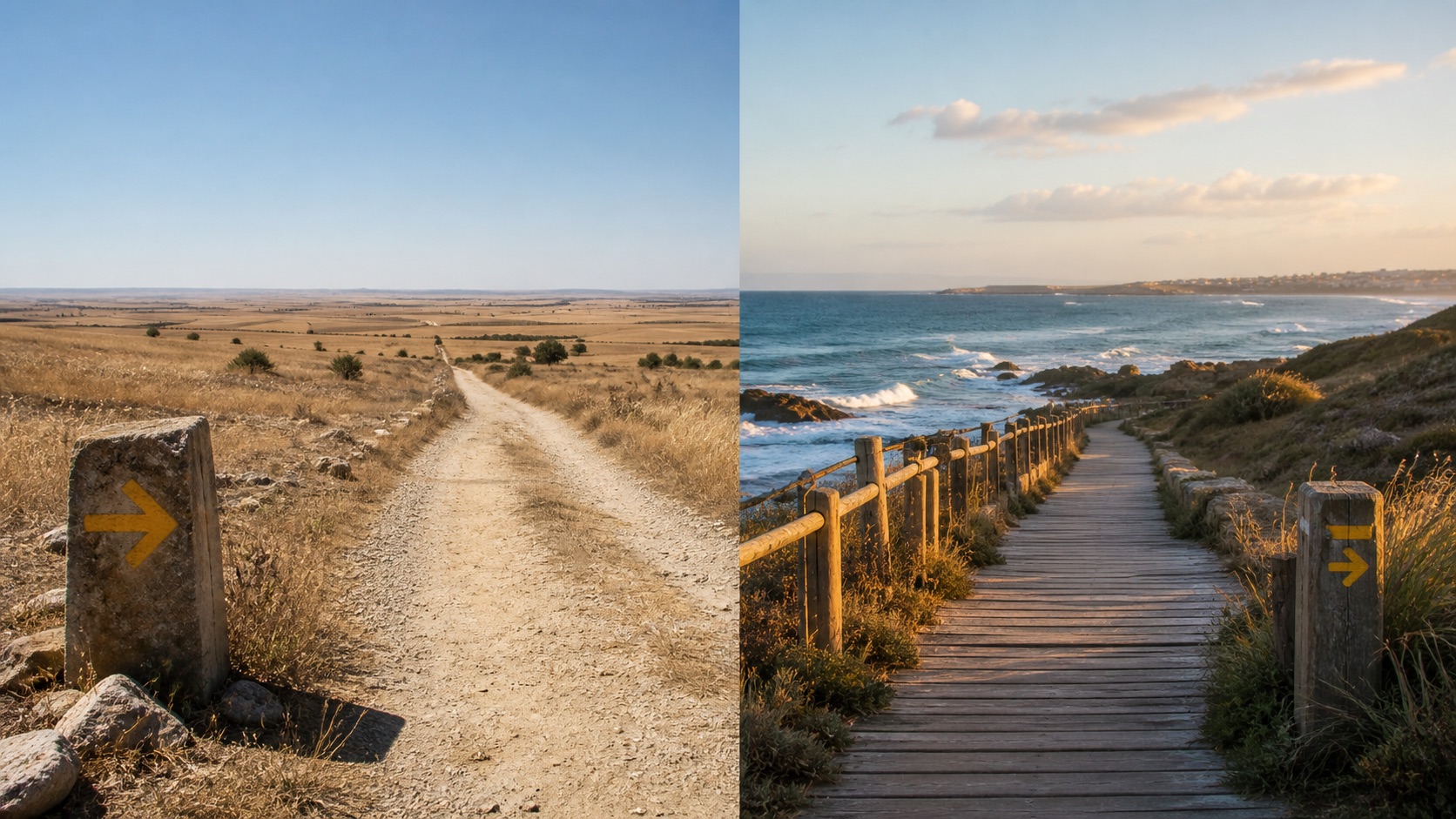
For most first-timers, the Camino Portugués Coastal from Porto is physically easier. Its terrain is mostly flat coastal walking, total distance is around 280 km, and the social atmosphere is calmer than the Francés. The Camino Francés from Sarria is the easier choice for community: it carries the densest pilgrim traffic on any route and the best beginner infrastructure for albergues, food, and pharmacies.
Choose by what you want the trip to feel like. If your knees worry you, walk the Portugués. If you want the classic social geometry — strangers becoming a temporary family over evening meals — walk the Francés from Sarria. Both are honest first Caminos.
When the Norte, Primitivo, or Inglés make sense instead
The Camino del Norte (~825 km along Spain's Atlantic coast) is the right choice for confident hikers who want fewer crowds and dramatic ocean scenery, at the cost of steeper terrain and sparser albergue density. The Camino Primitivo (~313 km from Oviedo) is the oldest and most mountainous route — beautiful but technically demanding. The Camino Inglés (~118 km from Ferrol) is the shortest route that still earns a Compostela, suited to pilgrims with very limited time and a preference for quieter walking.
There is no single distance. Each route is its own commitment. A standard stage is 20–25 km and takes 4–7 hours of walking, with one rest day per week as a typical pattern. The Camino Francés is typically split into about 33 stages over four to five weeks; the Portugués Coastal in 12–14 stages over roughly two weeks.
| Route | Total distance | Typical days | Daily km range | Terrain difficulty | Crowd level |
|---|---|---|---|---|---|
| Francés (full) | ~780 km | 30–35 | 20–25 | Mountainous to rolling | Very high |
| Francés (Sarria) | ~115 km | 5–7 | 18–25 | Rolling green hills | Highest |
| Portugués Coastal | ~280 km | 12–14 | 20–25 | Flat coastal | Moderate |
| Norte | ~825 km | 32–36 | 20–25 | Hilly coastal | Low–moderate |
| Primitivo | ~313 km | 13–15 | 20–28 | Mountainous | Low |
| Inglés | ~118 km | 5–6 | 20–25 | Rolling | Low |
How many days a beginner should actually budget
The trap is treating walking days as calendar days. Add travel at both ends, at least one rest day per week, and a buffer day or two for blisters, weather, or the simple desire to stay an extra night in a town you like. A "two-week" Sarria-to-Santiago plan is really five to seven walking days plus four to seven days for travel, rest, and slack. Pilgrims who book a flight home the day they expect to arrive in Santiago are the ones who end up taxis-and-trains rushing the last stage.
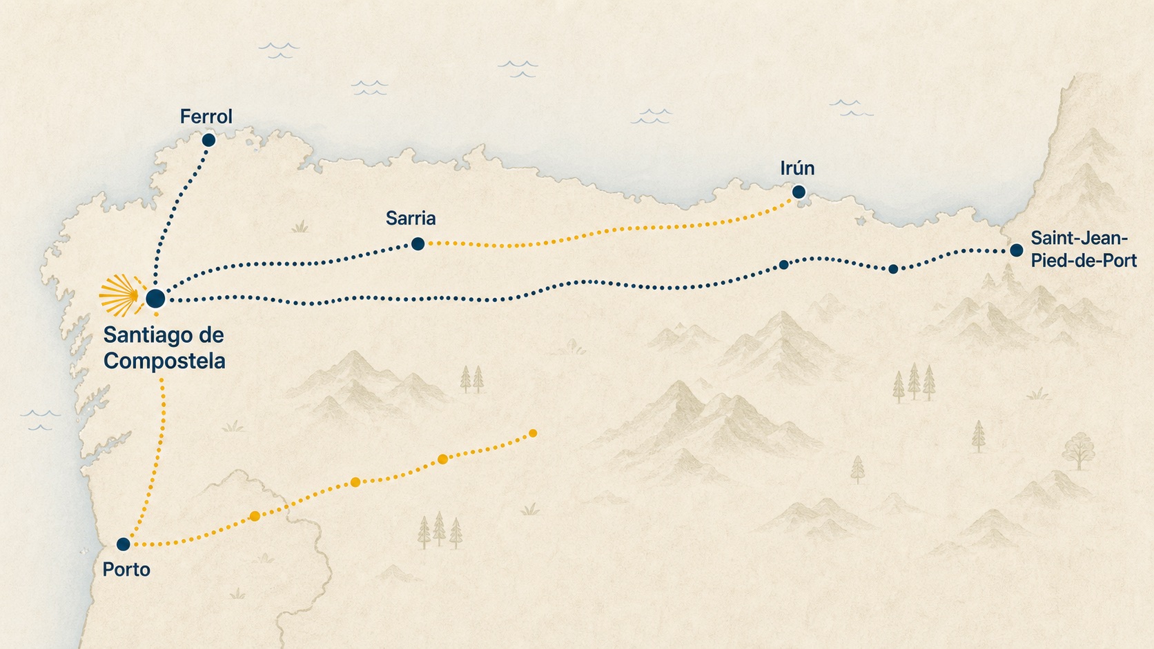
Every Camino route ends at the Plaza del Obradoiro in Santiago de Compostela, in front of the cathedral. Starting points vary: Saint-Jean-Pied-de-Port (Francés), Porto (Portugués Coastal), Irún (Norte), Sarria (last 100 km of the Francés), and Ferrol (Inglés). Sarria is the most popular start because it meets the 100 km minimum needed to receive the Compostela on foot — roughly 30% of all pilgrims in 2025 began there.
Why Sarria is the most popular starting point
Sarria sits exactly far enough from Santiago to qualify for the Compostela on foot — 100 km is the minimum, and Sarria is the first town beyond that threshold with a train station, regular bus service, and an entire ecosystem of pilgrim-ready hostels. For a first-timer with one week of leave, it is the path of least friction. The trade-off is density: the last 100 km in summer is the busiest stretch of any Camino, and you should book your first night and the night in Santiago in advance.
Extending past Santiago to Finisterre and Muxía
Many pilgrims walk on from Santiago to the Atlantic coast at Finisterre — roughly 87 km, three to four extra walking days. The route is quieter than anything leading into Santiago and ends on a clifftop above the ocean that the Romans called the end of the known world. Muxía adds another day and a half. Neither is required, and neither affects your Compostela, but both close the journey in a way that pilgrims who skip them sometimes regret.
The Francés is roughly 780 km from Saint-Jean-Pied-de-Port across mountainous-to-rolling terrain, with the highest pilgrim density and the best service network in northern Spain. The Portugués Coastal is roughly 280 km from Porto, with mostly flat coastal walking, a calmer social atmosphere, and fewer accommodation options at peak summer.
Camino Francés
Distance
~780 km
Difficulty
Strenuous
Best season
April – October
Highest pilgrim density, strongest community, best beginner infrastructure. The Napoleon crossing of the Pyrenees on day one is officially closed November through March. Hot on the Meseta in summer; bed pressure peaks May to August, especially from Sarria onward.
Camino Portugués Coastal
Distance
~280 km
Difficulty
Moderate
Best season
March – October
Flat coastal walking, calmer atmosphere, fewer total beds. Walkable in two weeks. Best in shoulder season — July and August fill the smaller towns and stretch the walking-to-bed ratio.
Cost, crowds, and weather windows
Daily budget on either route lands at €35–50 for a self-supported pilgrim staying in albergues (bed €10–15, menú del peregrino €12–15, breakfast €3–5, trail snacks). Private rooms push the total to €60–90. Crowds peak May to August on the Francés and July to August on the Portugués; September to mid-October is most pilgrims' favourite window for both routes — warm weather, harvest in La Rioja, thinning crowds. Galicia is wet regardless of season; pack rain gear in any month.
You can walk any Camino route without fluent Spanish. Waymarking is universal — yellow arrows and scallop shells from start to Santiago. Albergue check-in uses standard phrases that hospitaleros recognise across dozens of languages. Most pilgrims walking together share three or four common languages between them, and an offline phrasebook covers everything else.
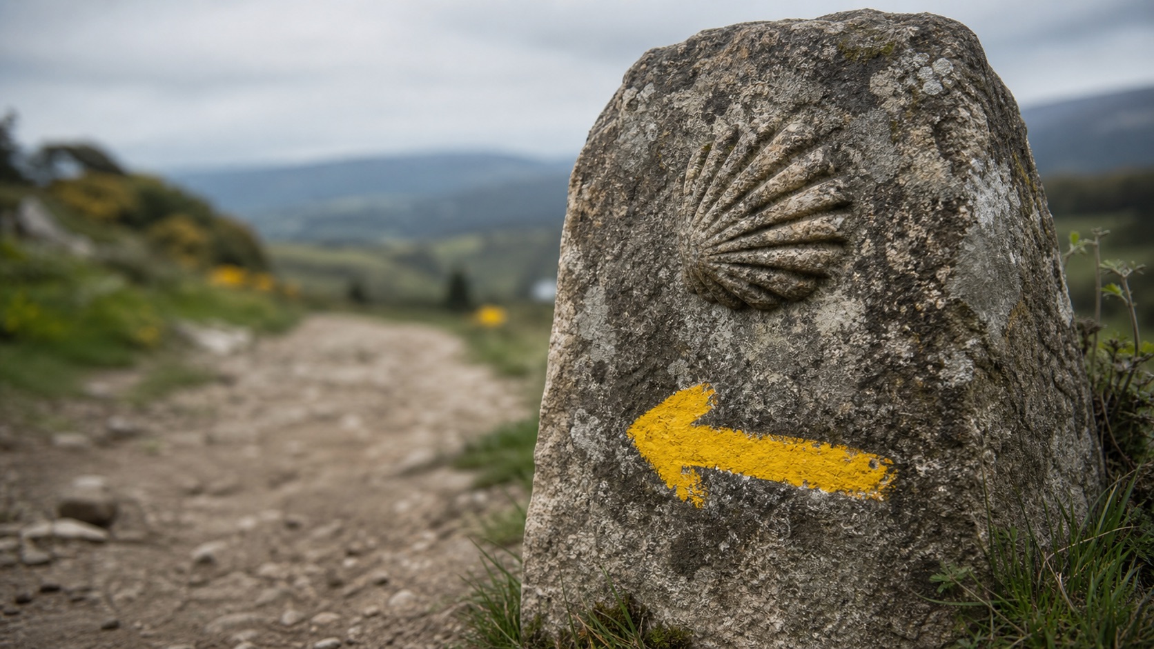
What waymarking looks like in practice
On the trail you are looking for two marks. The first is a yellow arrow — sometimes painted on a tree, sometimes on a kerbstone, sometimes on the back of a road sign. The second is a scallop shell, usually carved or set into stone, with the ribs pointing toward Santiago. Both are unmissable once your eye adjusts. The Francés is so densely marked that getting lost requires effort. Smaller routes ask for slightly more attention at trail junctions, but the symbology is identical.
Phrasebook essentials and offline translation
Download an offline translation app before you leave home and a small phrasebook in your own language. A handful of phrases — "do you have a bed for one tonight?", "how much, please?", "can you stamp my credential?" — covers most situations. For Korean, Japanese, and other less-commonly-supported languages, plan at least one offline resource per region so the moments that matter (a closed albergue, a pharmacy emergency) do not depend on signal.
Pick your starting point based on the walking days you actually have. Book one albergue for your first night. Train for 8–12 weeks at progressively longer distances. Pack under 10% of your bodyweight including water. Budget €35–50 per day. Everything else can be adapted on the trail.
For the long version of independent planning — pre-departure checklist, credential rules, replanning on trail when things break — see our full guide on how to plan your first Camino de Santiago. It is the companion to this article: this one helps you pick the route, the planning guide takes you from "I have a route" to "I am at the cathedral."
Frances Camino budget breakdown
A pilgrim staying in municipal and parish albergues, eating the menú del peregrino once a day, with breakfast and snacks bought in supermarkets, lands between €35 and €50 per day on the Francés. Private rooms, restaurant dinners, and laundry services push the total to €60–90. Add upfront costs for travel to Saint-Jean-Pied-de-Port or Sarria, the credential (€2–5), and any baggage transport days (€5–8 per stage). Budget separately for the post-arrival days in Santiago, which are not pilgrim-priced.
When the rest day matters most
The first three days are when blisters and overuse injuries appear, not fitness limits. The instinct is to push through. Don't. A rest day in week one — in a pharmacy town with a comfortable albergue — prevents the small problems that cause most first-timers to DNF in week two. The Compostela does not require continuous walking until the final 100 km. Before Sarria, taking a rest day or a half-stage is a legitimate planning tool, not a failure.
FAQ
What is the Camino de Santiago and which route should a first-time pilgrim actually pick?
The Camino de Santiago is a network of medieval pilgrimage routes that all end at Santiago de Compostela cathedral. For most first-timers, the Camino Francés from Sarria (the final 100 km) or the Camino Portugués Coastal from Porto are the best starting points: well-marked, well-equipped, and walkable in under two weeks.
Can I walk the Camino de Santiago if I don't speak Spanish?
Yes. Waymarking is the same on every route — yellow arrows and scallop shells — so you don't need Spanish to navigate. Albergue check-in is standardised and most hospitaleros recognise basic English. For shopping, food, and emergencies, an offline translator and a printed list of 30 essential phrases cover almost every situation a first-timer faces.
How much does it cost per day to walk the Camino?
Budget €35–50 per day for albergue beds (€10–15), one menú del peregrino (€12–15), breakfast (€3–5), and trail snacks. Private rooms push the total to €60–90. Summer means more bottled water; cooler months mean more café stops for warmth.
How fit do I need to be to walk the Camino?
If you can walk 15–20 km in one day without major pain, you are fit enough to start any beginner route. Most first-timers train for 8–12 weeks before departure, progressively building distance and adding pack weight. The first three days on trail are when blisters and overuse injuries appear, not fitness limits.
Do I need to book albergues in advance?
On the Camino Francés in July and August, the popular albergues fill by mid-afternoon, especially from Sarria onward. Outside peak summer, walk-ins work fine. The Portugués and Norte are less crowded but have fewer beds per town, so booking the next night by lunchtime is a safe pattern.
What happens if I get injured or an albergue is closed mid-trail?
Every main Camino route has at least one service town within roughly 10 km. If you cannot walk, taxis serve all main stages and luggage transfer services can carry your pack the next day. Closed albergues are common in shoulder season; the next pilgrim hostel is rarely more than 5–8 km further.
External citations
Oficina del Peregrino — official Santiago de Compostela pilgrim office
oficinadelperegrino.comAuthoritative source for annual pilgrim counts, Compostela issuance rules, and the 100 km / 200 km minimum requirement to receive the Compostela on foot or by bicycle.
Xunta de Galicia — Xacobeo programme
xacobeo.galGalicia's regional government runs the official Camino route information, waymarking standards, and Holy Year designations.
American Pilgrims on the Camino
americanpilgrims.orgNon-profit pilgrim association whose route overviews are the definitive English-language Camino reference for international first-timers.
La Compostela del Lector
You walked this guide to Santiago.
All 771 km, 0 stages, stamped end to end.